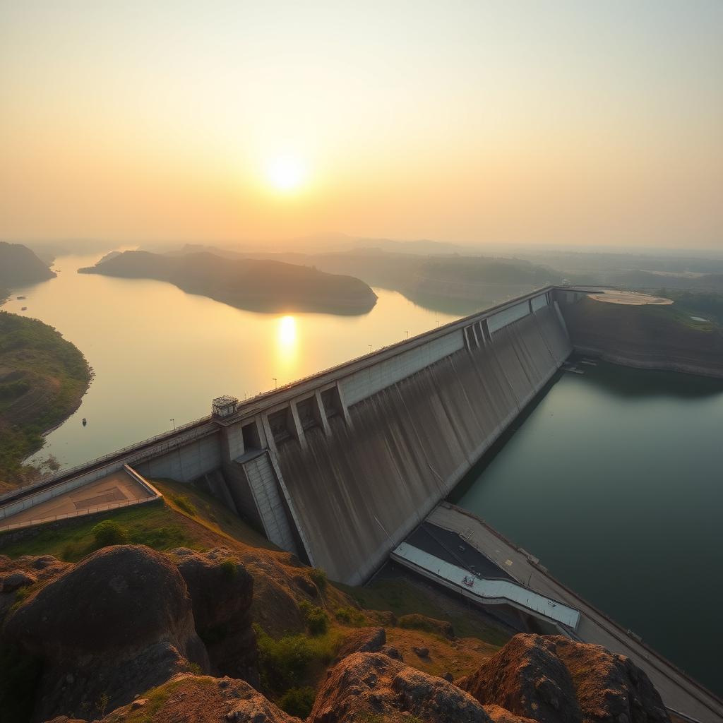
ହୀରାକୁଡ଼: ମାନବତାର ମହତ୍ତ୍ୱHirakud Dam: Engineering Marvel
ସମ୍ବଲପୁରର ହୀରାକୁଡ଼ ବନ୍ଧ ବିଶ୍ୱର ସବୁଠାରୁ ଲମ୍ବ ମାଟି ବନ୍ଧ — ୨୫.୮ କି.ମି ଲମ୍ବ। ମହାନଦୀ ନଦୀ ଉପରେ ଏହି ବନ୍ଧ ୧୯୫୭ରେ ନିର୍ମିତ। ଏହା ବନ୍ଧୁବାସୀ କାରଣ ଓ ଓଡ଼ିଶାର ବିକାଶର ପ୍ରତୀକ।The Hirakud Dam in Sambalpur is the world’s longest earthen dam — 25.8 km long. Built across the Mahanadi River in 1957, it prevents floods and symbolises Odisha’s development.
ଉଦୟଗିରି ଓ ଖଣ୍ଡଗିରି: ବୌଦ୍ଧ ଗୁମ୍ଫା | Udayagiri Khandagiri Caves
ସିମିଲିପାଲ: ଓଡ଼ିଶାର ପ୍ରକୃତି | Simlipal: Odisha Wildlife Sanctuary
ବନ୍ଧ ବିବରଣୀDam Specifications
ହୀରାକୁଡ଼ ବନ୍ଧର ମୁଖ୍ୟ ଦୈର୍ଘ୍ୟ ୪.୮ କି.ମି, ଏବଂ ଡାଇକ୍ ସହିତ ମୋଟ ୨୫.୮ କି.ମି। ବନ୍ଧର ଉଚ୍ଚତା ୬୦.୯୬ ମିଟର (୨୦୦ ଫୁଟ)। ଜଳାଶୟ ୭୪୩ ବର୍ଗ କି.ମି, ବିଦ୍ୟୁତ ଉତ୍ପାଦନ ୩୪୭.୫ MW। ବନ୍ଧରେ ୬୪ଟି ସ୍ଲୁଇସ୍ ଗେଟ୍ ଓ ୩୪ଟି କ୍ରେଷ୍ଟ ଗେଟ୍ ଅଛି। ଦୁଇଟି ପର୍ଯ୍ୟବେକ୍ଷଣ ଟାୱାର — ଗାନ୍ଧି ମିନାର ଓ ଜବାହାର ମିନାର।The main dam section is 4.8 km, with dykes totalling 25.8 km. Height: 60.96 m (200 ft). Reservoir area: 743 sq km. Power generation: 347.5 MW from two power houses. The dam has 64 sluice gates and 34 crest gates. Two observation towers — Gandhi Minar and Jawahar Minar — offer panoramic views of the reservoir.
ଜଳସେଚନ ଓ ବନ୍ଧୁବାସIrrigation and Flood Control
ହୀରାକୁଡ଼ ବନ୍ଧ ୧୫ ଲକ୍ଷ+ ହେକ୍ଟର ଜମିକୁ ଜଳସେଚନ ଦିଏ। ସମ୍ବଲପୁର, ବରଗଡ଼, ବଲାଙ୍ଗୀର ଓ ସୁବର୍ଣ୍ଣପୁର ଜିଲ୍ଲାର ୨,୩୫୫ ବର୍ଗ କି.ମି ଜମି ଖରିଫ୍ ଓ ରବି ଫସଲ ପାଇଁ ଜଳସେଚିତ। ମହାନଦୀ ଡେଲ୍ଟାର ୯,୫୦୦ ବର୍ଗ କି.ମି ଅଞ୍ଚଳ ବନ୍ୟାରୁ ସୁରକ୍ଷିତ। ବନ୍ଧ ନିର୍ମାଣରେ ୨୨୦୦+ ପରିବାର ବିସ୍ଥାପିତ ହୋଇଥିଲେ।The Hirakud Dam irrigates over 15 lakh hectares of farmland across Sambalpur, Bargarh, Bolangir, and Subarnpur districts — 2,355 sq km for kharif and rabi crops. It protects 9,500 sq km of the Mahanadi delta from devastating floods. Over 2,200 families were displaced during its construction, and 596 sq km of land was submerged.
ନିର୍ମାଣ ଇତିହାସ: ସ୍ୱାଧୀନତା ପରର ସ୍ୱପ୍ନConstruction History: A Post-Independence Dream
୧୯୪୬ ମସିହା ମାର୍ଚ୍ଚ ୧୫ ତାରିଖରେ ଓଡ଼ିଶାର ତତ୍କାଳୀନ ଗଭର୍ଣ୍ଣର ସାର୍ ହଥର୍ନ ଲୁଇସ୍ ଏହି ବନ୍ଧର ଆଧାରଶିଳା ସ୍ଥାପନ କରିଥିଲେ। ବ୍ରିଟିଶ୍ ଅଭିଯନ୍ତା ସାର୍ ଏମ୍. ଭିଶ୍ୱେଶ୍ୱରୟ୍ୟଙ୍କ ପ୍ରସ୍ତାବ ଉପରେ ଏହି ପ୍ରକଳ୍ପ ତିଆରି ହୋଇଥିଲା। ୧୯୪୮ ଅପ୍ରେଲ୍ ୧୨ରେ ପ୍ରଧାନମନ୍ତ୍ରୀ ଜବାହାରଲାଲ ନେହେରୁ ପ୍ରଥମ କଂକ୍ରିଟ୍ ସ୍ଥାପନ କରିଥିଲେ। ୧୯୫୭ ଜାନୁଆରୀ ୧୩ରେ ନେହେରୁ ଏହାକୁ ଉଦ୍ଘାଟନ କରିଥିଲେ। ସମୁଦାୟ ଖର୍ଚ୍ଚ ଥିଲା ₹୧,୦୦୦.୨ ନିୟୁତ (୨୦୨୩ରେ ₹୧୧୦ ବିଲିଅନ୍ ସମାନ)। ଏହା ସ୍ୱାଧୀନ ଭାରତର ପ୍ରଥମ ବହୁମୁଖୀ ନଦୀ ଉପତ୍ୟକା ପ୍ରକଳ୍ପ ଥିଲା।On 15 March 1946, Governor Sir Hawthorne Lewis laid the foundation stone. The project was proposed by legendary engineer Sir M. Visvesvaraya. On 12 April 1948, Prime Minister Jawaharlal Nehru laid the first batch of concrete. The dam was formally inaugurated by Nehru on 13 January 1957, at a total cost of ₹1,000.2 million (equivalent to ₹110 billion in 2023). It was India’s first major multipurpose river valley project after independence. Power generation began in 1956, reaching full capacity by 1966.
ବିଦ୍ୟୁତ ଉତ୍ପାଦନ: ଦୁଇଟି ଶକ୍ତି ଘରHydroelectric Power: Two Power Houses
ହୀରାକୁଡ଼ ବନ୍ଧରେ ଦୁଇଟି ଜଳବିଦ୍ୟୁତ ଶକ୍ତି ଘର ଅଛି। ପାୱାର୍ ହାଉସ୍ I (ବର୍ଲା) — ୨x୪୯.୫ MW, ୩x୩୭.୫ MW, ୨x୩୨ MW କାପ୍ଲାନ୍ ଟର୍ବାଇନ୍ (୨୫୯.୫ MW)। ପାୱାର୍ ହାଉସ୍ II (ଚିପଲିମା) — ବନ୍ଧରୁ ୧୯ କି.ମି ଦୂରରେ, ୩x୨୪ MW (୭୨ MW)। ସମୁଦାୟ ସ୍ଥାପିତ କ୍ଷମତା ୩୪୭.୫ MW। ଚିପଲିମାରେ ମହାନଦୀର ୮୦-୧୨୦ ଫୁଟ୍ ପ୍ରାକୃତିକ ଜଳପ୍ରପାତ ବ୍ୟବହାର କରାଯାଏ। ତିନୋଟି କେନାଲ୍ — ବରଗଡ଼ ମୁଖ୍ୟ କେନାଲ୍ (୪,୦୦୦ cfs), ସାସନ କେନାଲ୍, ଓ ସମ୍ବଲପୁର କେନାଲ୍।The dam supports two hydroelectric power houses. Power House I (Burla) at the dam’s toe contains Kaplan turbines: 2×49.5 MW, 3×37.5 MW, and 2×32 MW totalling 259.5 MW. Power House II at Chiplima, 19 km downstream, harnesses an 80-120 ft natural waterfall with 3×24 MW generators (72 MW). Total installed capacity: 347.5 MW. Three canals — Bargarh Main Canal (4,000 cfs discharge), Sason Canal, and Sambalpur Canal — distribute water for irrigation.
ନିମଗ୍ନ ମନ୍ଦିର: ଜଳତଳର ଐତିହ୍ୟSubmerged Temples: Heritage Beneath the Waters
ହୀରାକୁଡ଼ ବନ୍ଧ ନିର୍ମାଣ ସମୟରେ ୨୦୦ରୁ ଅଧିକ ପ୍ରାଚୀନ ମନ୍ଦିର ଜଳମଗ୍ନ ହୋଇଥିଲା। ପଦ୍ମପୁର ଗ୍ରାମର ପଦ୍ମାସେନୀ ମନ୍ଦିର ସବୁଠାରୁ ପ୍ରସିଦ୍ଧ। ଗ୍ରୀଷ୍ମ ଋତୁରେ ଜଳ ସ୍ତର କମିବା ସମୟରେ ପ୍ରାୟ ୫୦ଟି ମନ୍ଦିର ଦେଖାଯାଏ। ମଇ ଓ ଜୁନ୍ ମାସରେ ନୌକା ଯାତ୍ରାରେ ଏହି ମନ୍ଦିରଗୁଡ଼ିକ ଦେଖିହୁଏ। ଦୁଇଟି ଶିଳାଲେଖ (ଶିଳା ଲେଖା) ମିଳିଛି ଯାହା ପଦ୍ମାସେନୀ ମନ୍ଦିରର ଇତିହାସ ବିଷୟରେ ନୂଆ ତଥ୍ୟ ଦିଏ। ସ୍କୁବା ଡାଇଭିଙ୍ଗ୍ ପ୍ରେମୀମାନଙ୍କ ପାଇଁ ଏହା ଏକ ଅଦ୍ଭୁତ ଅନୁଭୂତି। ବନ୍ଧ ନିର୍ମାଣରେ ୨୦୦+ ଗ୍ରାମ ଜଳମଗ୍ନ ହୋଇଥିଲା।Over 200 ancient temples were submerged when Hirakud Dam was built. The most famous is the Padmaseni Temple of Padmapur village — one of the oldest settlements in the region. During summer, receding water reveals about 50 temples, visible by boat in May and June. Two inscribed stones (“Shila Lekha”) recovered from the Padmaseni temple have rekindled historical interest. The site attracts scuba diving enthusiasts. Over 200 villages were permanently submerged by the reservoir.
ରାମସାର୍ ଆର୍ଦ୍ରଭୂମି: ଜୈବ ବିବିଧତାର କେନ୍ଦ୍ରRamsar Wetland: A Biodiversity Hotspot
୨୦୨୧ ଅକ୍ଟୋବର ୧୨ରେ ହୀରାକୁଡ଼ ଜଳାଶୟକୁ ରାମସାର୍ ଆର୍ଦ୍ରଭୂମି (ସାଇଟ୍ ନଂ ୨୪୯୪) ଭାବେ ଘୋଷଣା କରାଗଲା। ଏହି ଜଳାଶୟରେ ୧୩୦ରୁ ଅଧିକ ପକ୍ଷୀ ପ୍ରଜାତି ଦେଖାଯାନ୍ତି। ସମ୍ପ୍ରତି ଗଣନାରେ ୪.୨୧ ଲକ୍ଷ ପ୍ରବାସୀ ପକ୍ଷୀ ଗଣାଯାଇଛି। ନୂଆ ୫ଟି ପ୍ରଜାତି — ରଡି କ୍ରେକ୍, ଗ୍ରେଟର୍ ପେଣ୍ଟେଡ୍ ସ୍ନାଇପ୍, ପେଣ୍ଟେଡ୍ ଷ୍ଟର୍କ, ଲିଟଲ୍ ଗଲ୍ ଓ ସାଣ୍ଡରଲିଙ୍ଗ୍ ଦେଖାଯାଇଛନ୍ତି। ବିପଦଗ୍ରସ୍ତ ମାଛ ପ୍ରଜାତି, ମାଛ ଧରା ସମ୍ପ୍ରଦାୟର ଜୀବିକା, ଏବଂ ବର୍ଷାରେ ୩୦,୦୦୦+ ପର୍ଯ୍ୟଟକ ଆସନ୍ତି। ଡେବ୍ରିଗଡ଼ ବନ୍ୟପ୍ରାଣୀ ଅଭୟାରଣ୍ୟ ନିକଟରେ ଅବସ୍ଥିତ।On 12 October 2021, Hirakud Reservoir was designated Ramsar Wetland Site No. 2494. It hosts over 130 bird species, with a recent census counting 4.21 lakh migratory birds. Five new species — Ruddy Crake, Greater Painted Snipe, Painted Stork, Little Gull, and Sanderling — were recently recorded. The reservoir supports endangered fish species, local fishing communities, and attracts over 30,000 tourists annually. The nearby Debrigarh Wildlife Sanctuary adds to the ecological richness.
ପର୍ଯ୍ୟଟନ ଓ ଆକର୍ଷଣTourism and Attractions
ହୀରାକୁଡ଼ ବନ୍ଧ ପର୍ଯ୍ୟଟକମାନଙ୍କ ପାଇଁ ଏକ ପ୍ରମୁଖ ଗନ୍ତବ୍ୟ। ଗାନ୍ଧି ମିନାର ଓ ଜବାହାର ମିନାରରୁ ୫୫ କି.ମି ଲମ୍ବ ହ୍ରଦର ମନୋରମ ଦୃଶ୍ୟ ଦେଖାଯାଏ। ରୋପ୍ୱେ ସୁବିଧା ଉପଲବ୍ଧ। ହ୍ରଦରେ ଅନେକ ଦ୍ୱୀପ ଅଛି — ଗୋଟିଏ ହେଉଛି କାଟେଲ୍ ଆଇଲ୍ୟାଣ୍ଡ୍। ଚିପଲିମାରେ ଘଣ୍ଟେଶ୍ୱରୀ ଦେବୀ ମନ୍ଦିର, ରାଜ୍ୟ ପଶୁପାଳନ ଫାର୍ମ ଅଛି। ଡେବ୍ରିଗଡ଼ ବନ୍ୟପ୍ରାଣୀ ଅଭୟାରଣ୍ୟ ନିକଟରେ। ବର୍ଷା ଋତୁରେ ବନ୍ଧ ଦ୍ୱାର ଖୋଲା ଦୃଶ୍ୟ ଅତ୍ୟନ୍ତ ମନୋରମ। ଅକ୍ଟୋବର-ମାର୍ଚ୍ଚ ଭ୍ରମଣ ପାଇଁ ଉତ୍ତମ ସମୟ।Hirakud Dam is a major tourist destination. The Gandhi Minar and Jawahar Minar observation towers offer breathtaking views of the 55 km long lake. A ropeway ride is available. The reservoir contains several islands, including the famous Cattle Island. At Chiplima, visit the Ghanteswari Temple and the state livestock breeding farm. The Debrigarh Wildlife Sanctuary is nearby. The sight of gates opening during monsoon is spectacular. October to March is the best time to visit.
ପରିବେଶ ପ୍ରଭାବ ଓ ବର୍ତ୍ତମାନର ଆହ୍ୱାନEnvironmental Impact and Current Challenges
ବନ୍ଧ କର୍ତ୍ତୃପକ୍ଷଙ୍କ ତଥ୍ୟ ଅନୁଯାୟୀ ରେତ ଜମା (siltation) କାରଣରୁ ବନ୍ଧର ଜଳ ଧାରଣ କ୍ଷମତା ୨୪% କମିଯାଇଛି। ଶିଳ୍ପ ପ୍ରତିଷ୍ଠାନ ପାଇଁ ଜଳ ବଣ୍ଟା ନେଇ କୃଷକମାନେ ବିରୋଧ କରିଛନ୍ତି — ୩୦,୦୦୦+ କୃଷକ ମାନବ ଶୃଙ୍ଖଳ ଗଠନ କରିଥିଲେ। ଝାରସୁଗୁଡ଼ା ଓ ସମ୍ବଲପୁରର ଖଣିଜ ପ୍ରକ୍ରିୟାକରଣ ଓ ତାପବିଦ୍ୟୁତ ପ୍ଲାଣ୍ଟ ପାଇଁ ଜଳ ବ୍ୟବହାର ବିବାଦୀୟ। ଆନ୍ତର-ବେସିନ୍ ଜଳ ସ୍ଥାନାନ୍ତରଣ ଯୋଜନା ମଧ୍ୟ ଚର୍ଚ୍ଚାରେ ଅଛି। ତଥାପି, ହୀରାକୁଡ଼ ଓଡ଼ିଶାର ଅର୍ଥନୀତିର ମେରୁଦଣ୍ଡ ରହିଛି।Dam authority statistics show water holding capacity has reduced by 24% due to siltation. Over 30,000 farmers formed a human chain protesting water allocation to industries in Jharsuguda and Sambalpur — mineral processing and thermal power plants. Inter-basin water transfer plans are under discussion as part of India’s river interlinking project. Despite challenges, Hirakud remains the backbone of Odisha’s economy, supporting agriculture, industry, and livelihoods across the Mahanadi basin.
ମହାନଦୀ ନଦୀ: ହୀରାକୁଡ଼ର ଜୀବନରେଖାMahanadi River: The Lifeline Behind Hirakud
ମହାନଦୀ ଭାରତର ଅନ୍ୟତମ ପ୍ରମୁଖ ନଦୀ — ଛତିଶଗଡ଼ର ସିହାୱା ପାହଡ଼ରୁ ବାହାରି, ୮୬୦ କି.ମି ଯାତ୍ରା କରି ବଙ୍ଗୋପସାଗରରେ ମିଶେ। ବନ୍ଧ ନିର୍ମାଣ ପୂର୍ବେ ମହାନଦୀକୁ “ଓଡ଼ିଶାର ଦୁଃଖ” କୁହାଯାଉଥିଲା — ବାରମ୍ବାର ଭୟାନକ ବନ୍ୟା ହେଉଥିଲା। ନଦୀର ଜଳଗ୍ରହଣ କ୍ଷେତ୍ର ୮୩,୪୦୦ ବର୍ଗ କି.ମି, ଶ୍ରୀଲଙ୍କାର ଦୁଇଗୁଣରୁ ଅଧିକ। ପ୍ରମୁଖ ସହାୟକ ନଦୀ — ଶିଓନାଥ, ହାସଦେଓ, ମାଣ୍ଡ, ଇବ୍, ଜଙ୍କ, ଓଙ୍ଗ ଓ ତେଲ୍। ହୀରାକୁଡ଼ ଏହି ବିଶାଳ ନଦୀର ଶକ୍ତିକୁ ନିୟନ୍ତ୍ରଣ କରି ଓଡ଼ିଶାର ଅର୍ଥନୀତିକୁ ରୂପାନ୍ତର କରିଛି।The Mahanadi is one of India’s major east-flowing rivers — originating from the Sihawa Hills in Chhattisgarh, traveling 860 km before merging with the Bay of Bengal. Before the dam, the Mahanadi was called the “Sorrow of Odisha” for its devastating floods. The catchment area spans 83,400 sq km — more than twice the area of Sri Lanka. Major tributaries include Seonath, Hasdeo, Mand, Ib, Jonk, Ong, and Telen. Hirakud tames this mighty river, transforming Odisha’s economy and protecting millions from floods.